


벚꽃지도- 한눈에 보는 전국 벚꽃 개화일과 명소 정보 is a practical guide for anyone planning a spring outing to see cherry blossoms across Korea. The app consolidates a nationwide map of popular blossom spots, provides regional estimates for flowering and full bloom dates, and offers detailed attraction pages so users can choose the best times and places for photos, walks, or family trips. It highlights likely peak periods and notes nearby facilities such as parking and restrooms to make planning easier.
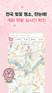
Nationwide map that displays major cherry blossom locations so you can see hotspots at a glance and plan routes across regions from Jeju to Seoul.
Regional estimated bloom and full bloom dates to help time visits; estimates are updated seasonally and reflect regional patterns.
Find nearby cherry blossom spots using your current location and open attraction pages that list address details and practical information about facilities.
With 벚꽃지도- 한눈에 보는 전국 벚꽃 개화일과 명소 정보 you can save time by checking bloom estimates and spot details in one place. The app is useful for families, couples, photographers, and travelers who want clear timing and location information for spring outings.
Blooming dates are estimates and can change quickly depending on weather conditions. The app is seasonal and most useful during the cherry blossom period, and it may not include every small or unofficial local viewing spot. Location-based features require enabling location services for accurate results.
Download 벚꽃지도- 한눈에 보는 전국 벚꽃 개화일과 명소 정보 to plan your cherry blossom visits with up-to-date estimates and concise spot information.