
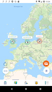
GeoGps is a compact GPS toolkit that provides accurate coordinates, route recording and secure location sharing for outdoor navigation and field work. GeoGps displays latitude and longitude in multiple formats, shows altitude and speed, and offers a compass view for quick orientation.
Start a tracking session to record a route, place waypoints as you move, and export results for analysis. GeoGps uses the device GPS and map layers to visualize position; tracking modes balance accuracy and battery use so you can choose what suits your activity.
GeoGps requests location access to provide navigation and recording features and optional storage access to save exported files. Recorded data is kept on your device unless you choose to share or export it. You control what is shared and when.