
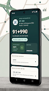

KM+ Rodovias is a practical location tool for drivers and logistics teams working on São Paulo state highways. KM+ Rodovias displays your real-time kilometer and meter position, detects the highway automatically and presents a simple, distraction-minimizing interface so you can report precise locations for emergencies, deliveries or roadside incidents as soon as the app opens.
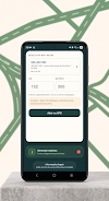
This app continuously reads GPS and matches your coordinates against preloaded highway reference data to determine the current km+meter position. Automatic identification eliminates the need to manually pick a highway: open the app and it will show the concession name, highway number and the current kilometre plus meters. You can also search directly by a km+meter value to jump to any point on a road, then open that location in an external mapping app or Street View for a visual check or turn-by-turn guidance.
The user interface focuses on a few clear controls so you can operate the app safely while mobile. A single screen presents your detected highway and the current km+meter reading; touch controls allow searching by km+meter, opening the point in a map application or copying coordinates to the clipboard for messages. Map gestures such as pinch-to-zoom and pan are available when the map view is open, and settings let you choose map detail level and whether to use metric display formats, keeping the controls familiar and easy to learn.
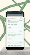
Because mobile coverage can be sparse along some corridors, KM+ Rodovias supports downloading highway datasets in advance. After you download the relevant sections, the app calculates position locally from GPS without needing an internet connection. This offline capability conserves mobile data and maintains functionality in tunnels, rural stretches and weak-signal areas. You can manage downloads by concession lot or corridor, so the app footprint remains reasonable on your device.
The system uses GPS positioning combined with linear references from highway datasets; readings are auxiliary and intended for reporting and navigation support rather than replacing official signage or field inspection. Factors such as GPS error, tunnel coverage, tall infrastructure or weather can introduce position variance. KM+ Rodovias indicates confidence levels and encourages users to validate critical calls with on-site assessment or the official road authority references when necessary.
The visual design emphasizes legibility and quick comprehension: high-contrast text for kilometre and meter readouts, clear highway labels and unobtrusive map overlays. When you open a specific km+meter location, a marker shows the exact linear reference on the map and, where available, a Street View preview link lets you confirm surrounding features. The style choices reduce distraction during driving and prioritize the most relevant information for operational use.
Rather than a traditional progression system, the app’s ongoing value grows as you build local caches and learn corridor behavior. Frequent routes become faster to access once datasets are downloaded. Settings allow brief customization such as display precision (how many meters are shown), preferred map provider for opening points, and whether new highway datasets download automatically over Wi-Fi. These options help tailor the experience to fleet needs or individual drivers.
KM+ Rodovias aims for a minimal learning curve: minimal screens, clear prompts and short on-boarding guidance that explains data download and search operations. The interface is optimized for readability while driving and supports larger font sizes through accessibility settings in the device. The app also exposes share and copy functions for easy reporting to emergency services, dispatchers or colleagues, streamlining communication when speed and clarity matter.
Coverage focuses on multiple São Paulo concession lots and major corridors such as Anhanguera-Bandeirantes, Ayrton Senna/Carvalho Pinto and Castello Branco. Typical users include professional drivers, logistics coordinators, emergency responders and maintenance teams who need fast, verifiable positioning for incidents, deliveries or inspections. Regularly used for roadside reporting, delivery verification and offline navigation support, KM+ Rodovias helps reduce time spent locating linear references.
The app processes GPS on-device to calculate position against downloaded highway maps; only user-initiated sharing sends a location externally. Periodic dataset updates improve accuracy and coverage as concession authorities publish revisions; the app notifies when new highway data is available for download. If you need help, in-app help screens describe common workflows and troubleshooting steps to get you back on the road quickly.